


What Jobs Can You Get with a Master's in Public Health?
Experts predict healthcare employment will grow 13 percent from 2021 [...]
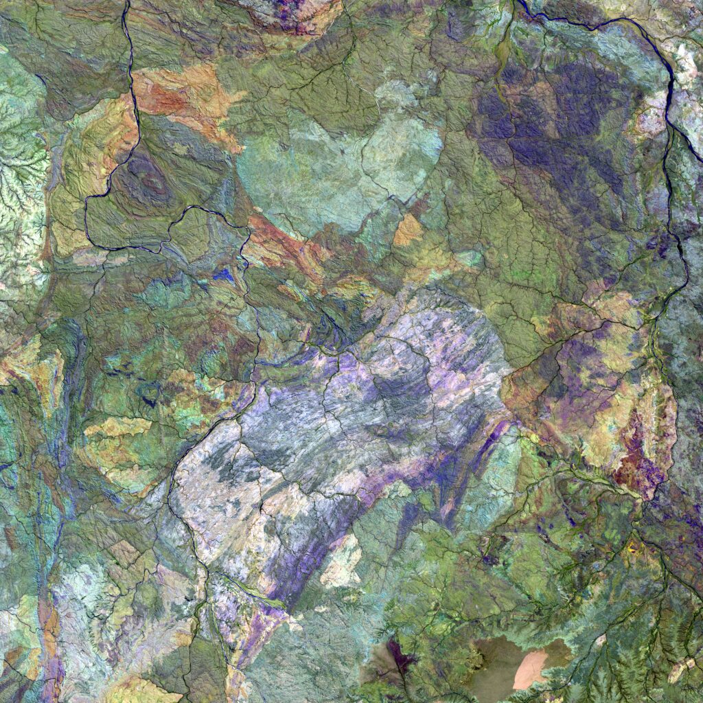
The world has dimension. It has valleys and peaks, soils and sands, and ice and water. Geographic Information Systems (GIS) helps us see, reach, and study all its elements.
GIS has become an increasingly popular university major. According to the University of Michigan, researchers are applying spatial technologies “in a widening range of fields, from archaeology and art history to land-use management and social work.”
Careers in GIS are multiplying and evolving, and GIS is quickly becoming a required skill for many other careers.
| University and Program Name | Learn More |
|
University of Washington:
Master of Science in Information Management
|
Candidates for a Master’s degree in Geographic Information Systems must first complete a Bachelor’s degree in GIS. It can mean a real difference in income and career potential. Payscale.com puts the median salary for those with a B.S. in GIS at $54,557. However, positions utilizing GIS skills vary in scope and by industry sector. Some jobs use GIS as part of their job description while others place it at the center. With that understood, Payscale sees careers in GIS paying $69,000 and more to those with advanced degree, experience, and tenure.
National Geographic defines geographic information systems as “a computer system for capturing, storing, checking, and displaying data related to positions on Earth’s surface.” A GPS traffic solution and Google Earth are common examples of the same technology,
GIS does not stop in measuring acreage or identifying borders. It has the ability to examine things vertically and horizontally. It can layer its observations as it studies landscapes. In that way, it locates streams, height and density of vegetation, population clusters, minerals and other resources, and more. GIS will examine, analyze, and report on just about anything requested. GIS advises governments and citizens on pollution, water resources, and migration trends.
A bachelor’s degree in GIS prepares students for careers using GIS. The major exposes students to computer software that displays visualization of the earth’s surface and geography. It integrates disciplines in computer sciences, earth science, environmental studies, geography, and physics.
Students learn advanced scripting, cartographic design, imagery processing, informatics, spatial analysis, visualization, and web mapping. More colleges and universities are offering degrees in GIS, but Texas State offers a typical curriculum where students select courses from available offerings:
Graduate school programs in GIS require more or less 35 hours plus labs and internships. They look for applicants with strong backgrounds in science and geospatial studies. But, they also like to see managerial and business skills. And, if you want to move to leadership positions, you need demonstrative leadership skills.
The applicants who prove to be the best fit for advanced studies and promising careers in GIS share personality traits:
Critical Thinking: Good candidates think critically. They enjoy problem solving and making data-based decisions. They are comfortable with data and spending time drilling down into resources.
Geographic Interest: Qualified graduate students have a foundation in geography. They understand it is more comprehensive than outline maps, continents, countries, and capitals. They understand geography also includes resources, trade routes, and ecosystems.
Spatial Comprehension: Graduate programs prefer students who can demonstrate familiarity with advanced geometric and spatial concepts and visualization. They understand the connection between data and 3-dimensional configuration of topology, surveying, and modeling.
Adaptability: Careers in GIS are still evolving and differentiating. Some are aligned with specific industries, and some are prerequisite to advancement. They must be flexible enough to move laterally or vertically as opportunity presents itself.
Communication Skills: GIS provides complete data that needs framing and presentation to people with less familiarity. Due to its focus on demonstration and expression of new perceptions, it requires good written and spoken communication skills.
Artistry: GIS communication depends on the ability to use color, dimension, and imagination to structure self-explanatory mapping and illustrations.
Passion: GIS is a recent development that invites and engages curiosity. It turns childhood interest in all things foreign and exotic into a passion for discovery and exploration through technology,
Most master’s in geographic information systems are non-research degrees. That means the emphasis is on application, so you are encouraged to make a decision early to move in the direction you want to pursue, including ecology, engineering, population, resources, sociology, and so on.
A master’s in geographic information systems opens doors in a number of science, public, and industrial sectors. These jobs are often tiered as a function of experience and tenure. The salaries vary across sectors and job titles, but some typical careers include these milestones:
GIS Analyst: Indeed puts the median salary for GIS Analysts at $56,560. They show jobs reported at Whirlpool, U.S. Department of Transportation, Bay Area Transit, and Southwest Gas, all paying more. An Analyst may be an entry level post or a senior level title.
Such jobs often work in the field to gather and check data. They perform the legwork to build databases that will analyze problems and solutions for employers.
GIS Manager: Indeed lists the median salary for GIS Manager at $68,698. They also report well paid positions for the City of Atlanta, Adecco, and Apex Systems. These jobs may describe management of other GIS personnel, but the title sometime refers to full-time or freelance project managers.
GIS Managers typically oversee the work and performance of GIS Analysts and others. They assess individual performance, budgets, and project outcomes.
Geographer: Payscale pegs the median salary for Geographer at $68,714, Bureau of Labor Statistics sees a higher median at $74,261 and a potential growth of 7% in jobs within 10 years.
Geographers might teach geography at any grade level. But, the job description has them studying the planet and its lands, waters, topographical features, and populations. They may also analyze the political and social structures that characterize with regions.
Cartographers & Photogrammerists: Cartographers & Photogrammetrists work at collecting, measuring, integrating, and interpreting geographic data to design and update maps and charts and collect, measure, and interpret geographic information to create and update maps and charts. Their reports support the work of regional planners, educators, emergency response, and mining and drilling.
The BLS forecasts a faster than average growth for such positions. They also show a median salary for Geographers employed by the Federal government at $87,580. And, $62,750 as a median wage among all employment sectors.
Land Surveyors: According to Payscale, the average income for Land Surveyors is $52,000. Land Surveyors report high job satisfaction, but the job is a career gateway to paths in civil engineering, resource management, and more.
Surveyors work in engineering, land development, and construction. They are responsible for accurately measuring and marking boundaries, elevations, and detail important to architects, contractors, lawyers, and more. BLS
predicts a faster growth than average for Land Surveyors before 2026.
Mapping & Surveying Technicians: The BLS sees a faster than average growth for this job now at an median wage of $42,450. All employers do not require a college degree for this entry level position.
These Technicians support Land Surveyors in the field. Techs measure, calculate, and record information with the aid of GPS, CAD, and/or GIS software.
Civil Engineers: A Masters in Geographic Information Systems can lead directly to a career path to Civil Engineer. It is not an engineering degree, but some engineering schools will structure a degree path integrating the strengths of both disciplines.
Payscale puts the current average wage at $65,000 and median of $63,955, They also cite similar wages in private and government employment.
Civil Engineers work with CAD software to plan and manage large and small construction projects. Working on public and private projects of scale, they may specialize in city management, water control, monument building, airports, and more. Civil Engineers can move on to focused career paths with even higher earnings.
Landscape Architects: Glassdoor posts a median wage of $61.396 for Landscape Architects. BLS puts the median wage just above that but shows much higher salaries in government employment.
Landscape Architects use sophisticated GIS and other technology to create public spaces for cities, institutions, and business campuses. They plan and place various flowers, trees, and shrubs along with concerns for permeable/non-permeable surfaces, water flow, and other environmental concerns.
The cost of earning a master’s in geographical systems varies widely. The degree is offered by the most respected universities in the country. Tuition partly depends on the university’s status as private or public. Just a few are shown here;
Many universities offer M.S. in GIS programs online at competitive rates. With this information, you can make a more focused decision on a career that professionals in Geographic Information Systems consider worth it.
The choice is yours, of course. But, the field offers opportunity, growth, and bridges to related careers. Its high level of job satisfaction reflects the job’s diverse activities, challenging tasks, field work, and creative and emerging technology. The job satisfaction amp up the personal return on investment.
Questions or feedback? Email editor@noodle.com
Experts predict healthcare employment will grow 13 percent from 2021 [...]

MPH programs at historically Black colleges and universities combat inequality [...]

Healthcare administrators work behind the scenes so that healthcare systems [...]

No buried treasure here. Give yourself the go-ahead on a [...]
Categorized as: Information Technology, Information Technology & Engineering